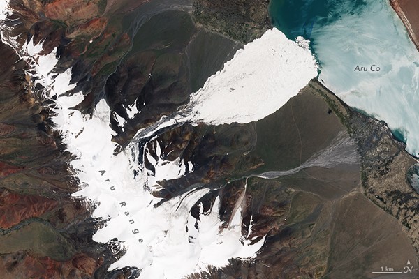
(Photos: USGS and ESA)
Some global warming impacts, like sea level rise, creep up on you a millimeter at a time. But others hit fast and hard, like a pair of 2016 avalanches in Tibet, when two giant glaciers crumbled, unleashing walls of ice that raced downhill at 120 kilometers per hour.
The first of the two avalanches, last July, killed nine yak herders along with scores of their animals when it ran six kilometers down a slope of the Aru Mountains of the Tibetan Plateau. A second avalanche, just 2.6 kilometers south and nearly as big, broke loose last September. Each of the Tibet avalanches spread icy slurry across across more than eight square kilometers, piling enough debris to fill 2,000 Olympic-size swimming pools.
“That one such event should occur is remarkable; two is unprecedented. The most likely explanation for the Tibet avalanches, and the associated glacial collapse, is climate change,” as University of Sheffield researcher Dave Petley wrote in an American Geophysical Union blog post last year.
Researchers describe these patterns as “a new kind of glacier collapse never documented before.”
Learning how and why the slides happened when they did has a very practical purpose. With enough information, experts could provide early warning for future large-scale glacier avalanches, potentially saving lives, according to French glaciologist Etienne Berthier, who spoke on April 25th at the European Geosciences Union General Assembly in Vienna, presenting an abstract of ongoing research into the Tibet avalanches.
“Other glaciers in the same range farther north have also been surging recently, which is an early warning sign. Could more such glaciers collapse in the future? We now have a recipe for how such disasters can happen,” Berthier said.

(Photo: NASA)
Based on what they already know, scientists could monitor glaciers in other parts of the world that are similar to the ones that disintegrated in the Aru Mountains, said University of Arizona hydrologist Jeffrey Kargel, who is also working on the study with researchers from France, Norway, China, Switzerland, and Canada. Tracking the signs identified by the research in Tibet could help warn other communities and people in harm’s way, Kargel said.
To pinpoint the cause of the avalanches, the scientists reconstructed the glaciers’ recent history using satellite data and matched it against climate records, which shows “clear and steady warming for 50 years, and a steep increase in precipitation in 1995,” Berthier said.
Between 1970 and 1995, the river of ice behaved normally, in balance with the regional climate. Then, bolstered by additional snowfall, it thickened in some places and started to speed up. Meanwhile, other sections of the glaciers thinned and cracked. The satellite pictures show discolored striations in the ice, and signs that the bottom end of the glacier was starting to melt rapidly. In the past 10 years, global warming brought unusual rains up to 5,700 meters to the Aru ice fields. The water seeped down to lubricate the bottom of the glacier. All that set the stage for “a new kind of glacier collapse never documented before,” as Berthier put it.
Similar changes are happening even faster in the tropical glaciers of South America, where ice clings precariously to a narrow strip of 6,000- to 7,000-meter peaks in the Northern Andes. At this latitude, there’s less of a winter season when ice can strengthen.
At the glacial headwaters of the Quillcay River Basin in Peru’s Cordillera Blanca Mountain Range, another group of scientists is already creating an avalanche and flood hazard map for the city of Huaraz, population 120,000, built astride the river, about 20 kilometers below a chain of lakes swelling with glacial melt. The biggest concern is Laguna Palcacocha: If an avalanche the size of the ones in Tibet were to crash into this lake, it would swamp the rock dam and send a giant flood cascading down the valley, where it could slash a path several hundred meters wide through the center of Huaraz.
“It would take about two hours to reach the town,” said Swiss researcher Holger Frey, showing a preview of the warning map at the EGU session on cryospheric hazards. It happened in 1941, when a flood killed about 2,000 people and, since then, the population has increased sixfold, according to Frey.
As global warming melts the glaciers, Laguna Palocha has grown dramatically. As of February of 2016, its volume had increased by more than 34 times since 1974. The continuing danger of large ice avalanches directly above the lake requires “new hazard and risk mitigation measures,” according to the researchers.
The lake is being monitored, and local authorities have even tried to install a drainage system to lower the lake level, but there are competing pressures to keep the water level high for irrigation and power production, Frey said. The team hopes its hazard map will help plan further mitigation measures, including efficient evacuation plans.


