Drought has long been hard to predict, but new research will now help forecasters develop early warnings.
By Bob Berwyn
A Sudanese woman fills water bottles held by a young boy about 60 kilometers north of El-Fasher, the capital of the North Darfur state, on February 9th, 2017. (Photo: Ashraf Shazly/AFP/Getty Images)
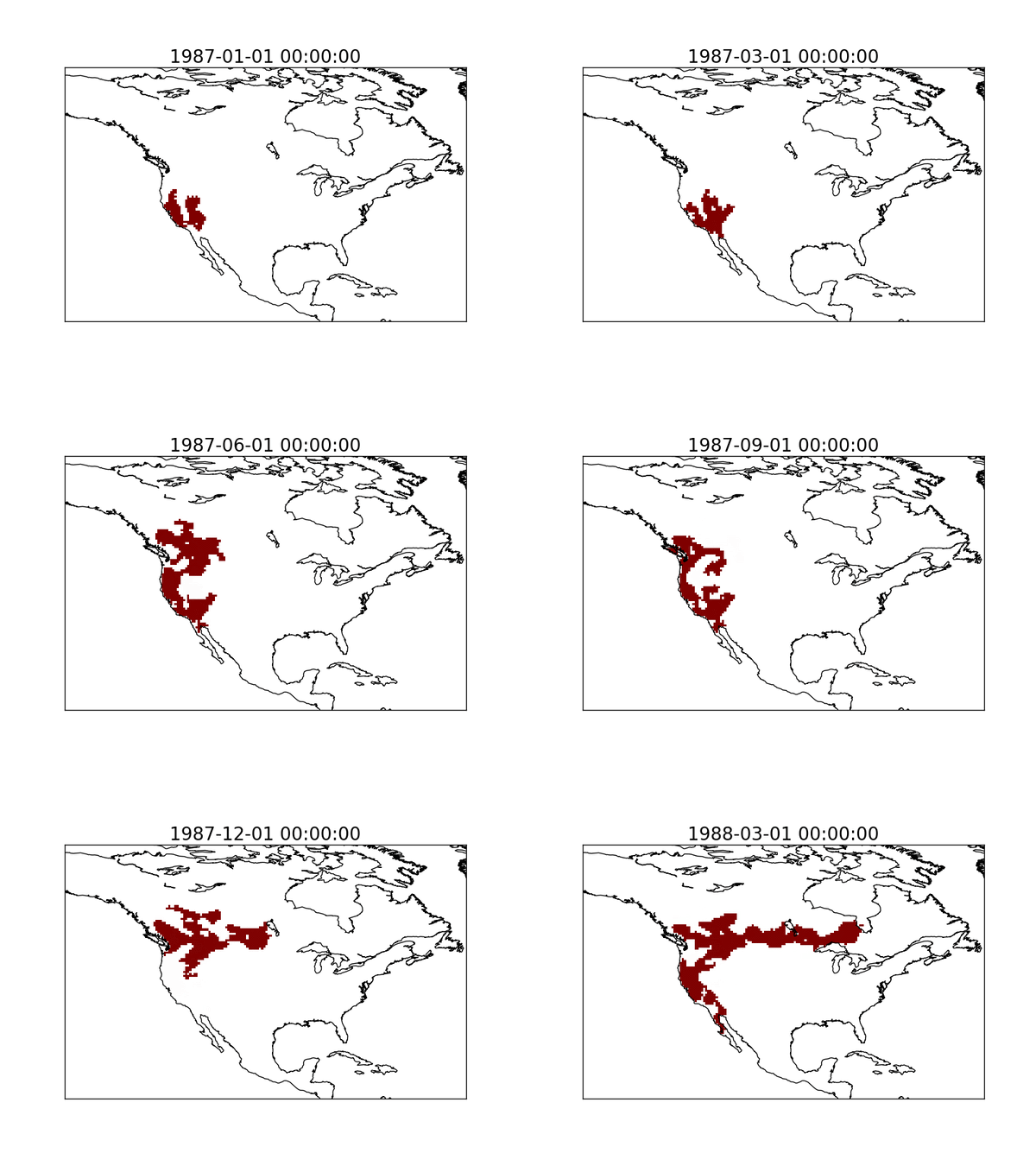
Droughts are large-scale phenomena that can morph through time and space, and accurately forecasting them has long proven an elusive goal for climate scientists and meteorologists. But a new study could help because it reveals certain quite-specific geographic patterns that some regional droughts follow over and over again.
After analyzing thousands of droughts on all continents over a 30-year period, an international team of researchers found that about 10 percent of droughts follow predictable tracks. Combining new models with existing forecasting tools, the findings will give scientists a jump on predicting droughts.
Better forecasting could help relief agencies avert humanitarian catastrophes in less-developed regions of the world, where droughts are a matter of life and death for millions. It can help water managers avert shortages and inform farmers about when, what, and if to plant. All of this is even more important in the context of global warming, which is already worsening droughts.
“Some intense droughts are like slow-motion tropical cyclones. They move and affect different areas, except it’s on a timescale of months to years instead of days to weeks,” says Julio Herrera-Estrada, a Ph.D. candidate in civil and environmental engineering at Princeton University who led the team, which included other scientists from the University of Southampton in the United Kingdom and theInternational Institute for Applied Systems Analysis in Austria. The study was published last week in the journal Geophysical Research Letters.
Since droughts can cover large areas, they are among the deadliest and most costly natural disasters. The University of California–Irvine estimates that the California drought cost the state $1.8 billion and more than 10,000 jobs in 2015. Globally, drought has claimed over a million lives and caused $60 billion in losses since 1974, according to an analysis by the United Nations Office for Disaster Risk Reduction. Currently, a drought centered around the Horn of Africa is putting millions of people at risk in Somalia, South Sudan, Nigeria, and Yemen.

(Map: Courtesy Julio Herrera-Estrada)
“I realized that, compared to other extreme events, there’s no good model for projecting droughts,” Herrera-Estrada says. “It’s hard to predict where a drought might start. That’s more of a random act of the atmosphere, like a persistent high-pressure system, or an El Niño. But once the drought starts, if we understand the dynamics, we might be able to predict how it will evolve.”
“For comparison, think of tropical cyclones. The science community has developed models, using statistics and physical drivers, with which they can simulate thousands or tens of thousands of hurricanes to forecast particular trajectories and the risk to particular coastal regions,” he says. “If we start seeing drought as dynamic events, as dry anomalies that travel, we might be able to forecast them in similar ways. So we looked: What are the important physical drivers that make them move?
The researchers on Herrera-Estrada’s team analyzed 1,420 droughts worldwide between 1979 to 2009. They found patterns on every continent and concluded that about 10 percent of the droughts — often the most intense — follow similar tracks. In the southwestern United States, droughts tend to move from south to north. In Australia, the researchers found two drought hotspots and common directions of movement, one from the East Coast in a northwest direction, the other from the central plains in a northeast direction.
The droughts the team studied tend to be the largest and most severe, with the highest potential for damage to the agriculture, energy, water, and humanitarian aid sectors.

A new study will contribute to better drought forecasting. (Map: Courtesy Julio Herrera-Estrada)
The modeling used in the new study would help avoid missed forecasts like in 2012, when a flash drought started in the southern Rockies in May and spread across the Midwest in just a few months, says Debasish Pai Mazumder, a climate scientist at the National Center for Atmospheric Research in Boulder, Colorado.
That drought seemed to start with a two-week heatwave in March. There was, he says, no underlying large-scale climate phenomenon suggesting drought development, so that the National Ocean and Atmospheric Administration’s seasonal forecast, focusing on precipitation and snowpack, missed the mark in terms of any sort of early drought warning, leaving ranchers and farmers high and dry.
Because droughts don’t stop at political boundaries, the study also highlights the importance of regional cooperation and sharing climate data across borders, the researchers concluded.


