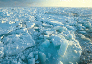
While the world’s eyes focus on the catastrophe in the Gulf, climatologists are tracking a decades-old cataclysm at the top of the world — dwindling Arctic sea ice.
This year is projected to surpass 2007’s summer sea ice minimum, when sailboats were seen navigating their way through large cracks in polar ice floes.
“Where Arctic ice used to be 3- to 5-meters thick in most places, now it’s tough to find ice that’s over 3-meters thick,” explained Ignatius Rigor, a climatologist at the University of Washington in Seattle. “Most of the Arctic is covered by 2-year-old ice. It used to be covered by ice that was 30 years old.”
A decade of warmer than normal Arctic air temperatures, along with warmer ocean waters moving their way north, are thought to be responsible.
Although records indicate that Arctic sea ice cover has been disappearing since the late 19th century, U.S. submarine data show a more recent appreciable dip in its thickness dating from the early 1980s.
Projections call for the Arctic Ocean to become open water, at least in summer, as early as 2040. The last three decades of loss — in both the volume and extent of summer sea ice and in more permanent multi-year Arctic sea ice packs — are climatologically unprecedented during the last few thousand years. And such loss can’t be explained by any known natural variability.
Even so, CryoSat-2, a $170 million ice-measuring polar satellite launched by the European Space Agency in April, will devote a large part of its mission to helping climate researchers understand the how and why of Arctic climate change. Specifically, CryoSat will measure the rate at which the thickness of Arctic sea ice changes over time.
ESA’s Ice Mission
the European Space Agency’s CryoSat mission is dedicated to precise monitoring of the changes in the thickness of marine ice floating in the polar oceans and variations in the thickness of the vast ice sheets that overlay Greenland and Antarctica. For more details on the mission, click here.

Currently in its commissioning and verification phase, ESA expects CryoSat’s scientific mission to begin in earnest this fall. (An earlier ice-measuring satellite, the original CryoSat, crashed near the North Pole shortly after takeoff in 2005.)
“CryoSat was designed to measure rates of change in elevation and thickness at monthly intervals over a greater area of the polar region’s ice cover than any of its predecessors,” said ESA geophysicist Mark Drinkwater. “This will give us robust evidence for seasonal and interannual variations in ice thickness.”
Traditionally, cloud cover could hamper orbiting satellites* such as the United States’ ICESat, which operates in the optical range. However, CryoSat is using a state-of-the-art radar altimeter that can pierce the polar cloud cover to better distinguish between electronic echoes from water and electronic echoes from ice.
By recording the distance between Earth and the satellite, Cryosat will be able to precisely measure changes in these ice floes’ height above the sea surface, with accuracies down to a centimeter.
Rigor notes that CryoSat’s lifespan of five-plus years is not long in terms of climate; to understand climate variability requires decades of data at the least.
Nonetheless, climatologists know that during winter, Arctic sea ice typically covers up to 15 million square kilometers, and that between Arctic summer and winter, an area roughly the size of Europe melts and then refreezes.
A permanent loss in such ice cover can create a warming loop: Earth reflects less solar radiation back into space, the underlying ocean absorbs more sunlight. This lessening in reflectivity, or albedo, in turn heats up both the Arctic’s ocean and surrounding atmosphere, causing a vicious cycle of melting ice and higher temperatures. That in turn impacts temperatures, temperature swings and sea level around the planet, as well as possibly causing irreversible changes in the Arctic itself.
“The short-term future of sea ice is mostly speculation; in the longer term it will continue to decline,” said Ron Kwok, a polar scientist at NASA’s Jet Propulsion Laboratory in Pasadena, who is also on CryoSat’s calibration and validation mission team. “There’s more [sea ice] variability now than we’ve seen in the past 30 years. There’s some instability in the Earth climate system that we simply don’t understand.”
Rigor says that the Arctic’s current sea ice retreat can’t be explained without also factoring in an increase in global greenhouse gases, which he notes are overwhelmingly due to human activity. But whether the melt results from burning fossil fuels or deforestation, the end game appears unchanged.
“In about 30 or 40 years, most of the ice at the polar cap will be gone by the end of summer,” said James Overland, an oceanographer at the National Oceanic and Atmospheric Administration in Seattle. “In the Arctic winter and spring, [the polar cap] will always have ice. But around the edges of the North Pole, north of Alaska and north of Europe, it’ll be ice free well into November.”
* Examples given in the sentence originally included Europe’s Envisat, which in fact is not blinded by weather because it operates in the microwave range. (Back)


