Forget about simply dreaming of a white Christmas. In many mountainous regions of the American West, which have historically been blanketed with snow from November through March, the Bing Crosby-style yearnings of the future may be for any fresh powder at all.
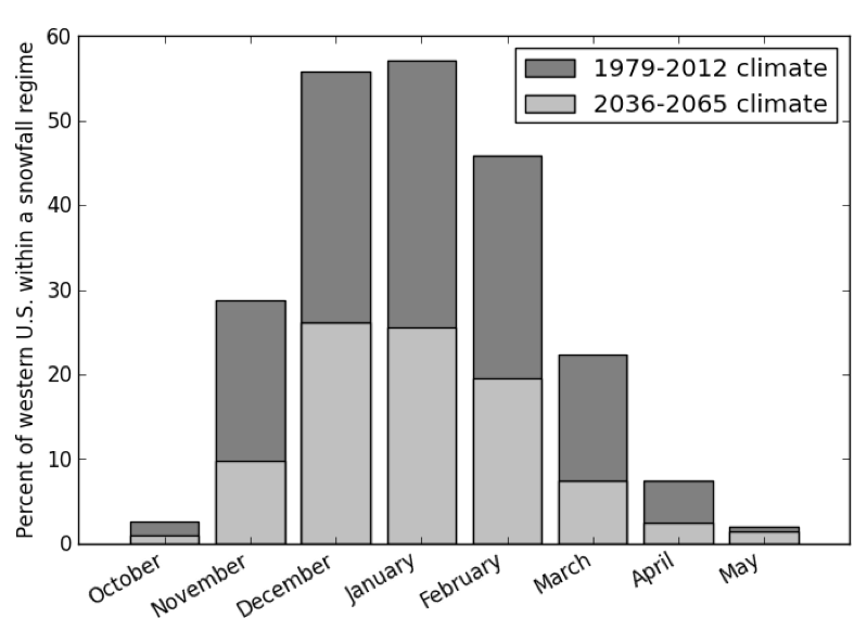
New research has painted a vivid picture of the global warming-induced fate of what currently are snow-peaked mountains across the region. Within 50 years, University of Idaho scientists concluded, the lower-elevation peaks could be wholly rained upon instead of receiving mixtures of snow and rain. And across much of the region, the snow season is expected to contract from five months every year to just three months.

Those were some of the findings of an attempt to model how global warming will shift rain-snow transition zones upward throughout a vast swath of the United States. It’s a swath of the nation where farmers and residents rely heavily on melting snowpacks for water supplies during the warmer months. That means the change from wintertime snow to rain could worsen both winter floods and summer droughts.
The researchers used observations and projections of temperatures and precipitation levels to estimate the likelihood of rain and snow throughout the region—both in the past and in the future. The results, summarized in the chart on the right, would be sobering for just about any winter sports junkie and worrying for any water manager.
“This is more of a start—a start to assessing the areas where we would expect to see a big transition,” says Timothy Link, a hydrology professor at the University of Idaho and one of the scientists who contributed to the peer-reviewed paper describing the modeling results. The paper is expected to be published soon in Geophysical Research Letters.
“There are watersheds which are expected to make wholesale shifts,” Link says. “We were able to show the areas where we have large contiguous land areas that are expected to undergo shifts in their hydrologic regime.”
The results will not, however, be consistent across the region.
“Large areas, particularly many that were previously strongly snow-dominated in March and April, will likely begin to experience increased frequency of rainfall during these months,” the scientists write in their paper. “Furthermore, results suggest that many mountainous areas will be characterized by a mixed rain-snow regime in November, in contrast to the historic strongly snow-dominated precipitation regime.”
The effects will be the strongest on the lower mountains, such as the Northern Rockies, North Cascades, and Blue Mountains.
Higher regions, including the Yellowstone area, the Uinta Mountains, the Bighorn Ranges, the Colorado Rockies, the high Sierra Nevada, and the mountains of east-central Idaho will be the least affected. Those areas are expected to remain relatively snow-dominated during winter, but could receive less snowfall during fall and spring.
Link says the data used to produce the maps in the paper would be made available to water managers, helping them plan for the alien hydrological cycles expected in the future.

(Chart: Geophysical Research Letters)


