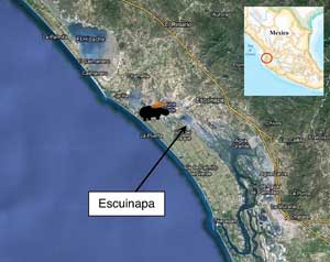
In mid-May of this year, an entire town moved to the beach for five days of partying. School was canceled and work was deferred for the thousands attending the annual Fiesta de Mar de las Cabras. They came mostly from Escuinapa, a town located one hour south of Mazatlán and 20 minutes inland from Playa Cabras.
According to organizers, it is the 105th year of the event, which had roots as an indigenous “pagan” festival to celebrate the sun god Yequi. Kids, parents and grannies listen to live music on the isolated beach. There is nothing around for miles except coconut trees and two impressive neighbors: the biggest wetland on the Pacific coast of Mexico, called the Marismas Nacionales; and the largest tourist “mega-project” in Mexico, which is about to hit high gear.
The town of Escuinapa is a patchwork of gray buildings surrounded by mango plantations. It is a humble place that suddenly finds itself at the feet of those two giants, who claim to be as big and friendly as the Big Friendly Giant in Roald Dahl’s book of the same name.

Likewise, these two giants are dream-catchers. The Nature Giant spins dreams of a healthy and bucolic lifestyle. It might be an antidote to its twin brother, the Money Giant, who trumpets dreams of wealth and growth.
While some are lured by their promises, others regard these giants with suspicion. Those who have read Dahl’s book know that most giants eat little children in their sleep. But might some giants make dreams come true?
The Nature Giant, the Marismas Nacionales (additional link here), is a system of coastal lagoons and wetlands spanning two states. Each state has a planned biosphere reserve — in Sinaloa state, home of Escuinapa, the reserve should be announced next February; while to the south, the reserve in Nayarit state was just decreed two months ago (located near the town of San Blas, not far from Puerto Vallarta).
As part of a United Nations initiative, the biosphere reserves would integrate human activities with the sustainable use of natural resources. They also set aside “core” areas for complete preservation. Both goals support healthy fisheries, a primary occupation for many coastal residents, which have been in extreme decline over the past decades. Shrimp fishing was a highly productive industry in Escuinapa until its crash — the 1,600 tons of shrimp brought ashore each year is now closer to 100 tons. By regulating the industry and setting aside core areas of preservation, the reserves hope to help shrimp stocks recuperate, alongside the countless commercial fish that use the wetland in key parts of their lifecycle.
In so doing, they conjure local fishermen’s lost dream — continuing to fish with their own boat and as their own boss.

On the flip side, fishermen are concerned that reserves will limit their fishing grounds — which is true, particularly in the short term. The reserve would also put restrictions on the growing agricultural industry surrounding the Marismas, with regulations on fertilizer/herbicide use and erosion caused by cattle.
When I was going through town, a meeting between government agencies and private organizations was held to draft the reserve’s management plan. I spoke to Miguel Cruz Nieto, director of conservation at Pronatura, the largest environmental group in Mexico, which was invited to participate in the plan drafting.
“People are resistant to environmental regulations — but they also realize that catastrophes like the Canal de Cuautla need to be avoided,” said Nieto. That man-made canal near San Blas opened in the 1970s to allow fishermen access to the ocean, but massive tidal water movement has left it more than a kilometer wide. Despite that boondoggle, people are concerned that the reserves will somehow handicap the Money Giant — the tourist developments that promise them so much wealth and growth.

The Money Giant is known as the CIP, a Spanish acronym that stands for “Planned Integral Center.” Reports (the link to the page in Spanish can be found here) say that it could become twice the size of Cancún, since the masterminds of the proposal — Fonatur, the Mexico government agency in charge of developing tourism — purchased twice as much land as it owns in Cancún.
The full size of the development will of course depend on the total amount of private investment. Twenty minutes from Escuinapa, the CIP is located between Mazatlán and Puerto Vallarta. Since the highway runs inland to avoid the flooded lands of the Marismas, the coastline has been kept mostly undeveloped, besides medium-scale agriculture and fishing. The miles of “untouched” beaches are now in the sights of tourism developers. Using the successful model of “Riviera Maya” in the Cancún area, they want to expand the “Riviera Nayarit” tourism corridor leading north of Puerto Vallarta. From the opposite end, south of Mazatlán, condominiums and hotels are springing up along lagoons to bridge that gap.
People in Escuinapa are very eager for the CIP and its potential to bring money to the area. Fortunes have already been made — the 80-year-old owner of the land purchased by Fonatur made millions of dollars and, in a gesture of giving back to the community, built a new school on the edge of Escuinapa. Hence, the general population frowns upon any restriction on the development.
“People don’t even want us to ask for a public review of the environmental impact report, because it slows down the process,” said Carlos Simental from the REDES group of environmental and business leaders of Escuinapa. “They have that much faith in the goodwill of the developers.”
Two weeks ago, Simental submitted the request for public review. “There is just too much at stake,” he said.
In the past, indigenous groups could traverse the 230 kilometers of the Marismas Nacionales by canoe during the wet season. However, water flow has become constricted in the last century and the Marismas are no longer seasonally connected. Six out of the seven rivers that drain into the Marismas have been dammed, and the last one has a proposal for a hydroelectric facility to power the CIP development and feed its water supply.
“Dams have other effects also,” Sandra Guido, director of the environmental group Conselva, told me. “They prevent rivers from flushing the fallen leaves [from seasonal tropical dry forests] which are used as organic matter in the lowlands; siltation and chemicals accumulate; and water availability allows agricultural operations to expand, which means deforestation for cleared lands, erosion and fertilizer runoff — all for something with a limited lifespan of a few decades, since dams fill up with sediment over time.”
However, it is impossible to build a development without water and power, so compromises are necessary.
One person finding a middle ground is mangrove expert Francisco Flores from the Institute of Maritime Sciences (UNAM-Mazatlán), who has been studying the Marismas his whole life. “There are ways to mitigate impact,” he said.
“Don’t let water flow be choked by roadways built up with dirt and rocks [instead, use bridges]. Reduce upstream erosion. Currently 230 annual tons of sediment wash into the Marismas, and the healthy normal is about 20 annual tons. This cuts off fresh water and creates salinization, which destroys the wetland. Mangroves prefer 15-20 [parts per million] of salt, versus the ocean, which is 30 ppm, and 100 ppm have been recorded in dying mangroves. Luckily, mangroves bounce back if given the proper water flow.”
The question is being posed whether these mega-scale projects are a good approach for our increasingly fickle climate. How do we make them sustainable, particularly if rain and temperature change? Are biosphere reserves sufficient antidotes to the possible side effects of dams, agriculture, and development? These Big Friendly Giants have good intentions, but they may either inadvertedly gobble some children along the way — that is, the prospects of the next generation — or keep our dreams intact.
Further down the coast, south of Puerto Vallarta, I would be looking at smaller scales of development and preservation, to see if there are other solutions besides the “super sized” approaches that we’ve come to rely on.
For more information: Voyage of Kiri homepage also has more photos and maps of the locations.


