Fueled by a record-warm ocean, Matthew is a storm unlike any yet seen in some parts of the Sunshine State.
By Eric Holthaus
South Florida resident James Balboni puts gas in a generator in preparation for Hurricane Matthew in Fort Lauderdale, Florida. (Photo: Rob Foldy/Getty Images)
Hurricane Matthew is heading straight for Florida, but the storm has already made its place in the history books.
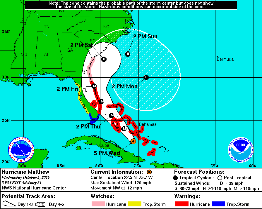
Since weather records began in 1851, no hurricane of Matthew’s predicted strength (Category 4, with sustained winds of at least 135 mph that the National Hurricane Center labels as “catastrophic”) has ever made landfall in Florida north of West Palm Beach. That streak is likely to end in a big way on Thursday.

(Image: National Hurricane Center)
Should Matthew take the most likely track as of late Wednesday, it could bring severe coastal flooding and wind speeds of between 75 and 135 mph to nearly all of Florida’s east coast, from Fort Lauderdale northward to Jacksonville and beyond, as far up as the Carolinas. Matthew is likely to move parallel to the coastline, giving it the ability to simultaneously draw strength from the warm Gulf Stream and directly affect parts of the most vulnerable coastline in America. The National Hurricane Center estimates that storm surges of five to eight feet and waves of up to 30 feet could erode beaches vital to the state’s tourism economy, and threaten coastal infrastructure including homes and highways.
Simply put: If Florida’s disaster preparedness officials wanted to script a worst-case scenario for the state, it would look a lot like Hurricane Matthew. This is a nightmare hurricane.
Officials aren’t taking any chances: South Carolina Governor Nikki Haley has ordered the mandatory evacuation of about a million coastal residents, and Florida Governor Rick Scott said that those in the storm’s path failing to prepare could be facing “the difference between life and death.” Traffic cameras captured scenes near Charleston, South Carolina, in which the flow of Interstate 26 was altered to direct all lanes away from the coast.
Even in south Florida, Thursday marks 4,000 days since the last so-called “major” hurricane made landfall — Wilma, on October 24th, 2005. (Major hurricanes have sustained winds in excess of 115 mph.) That is to say, even the most hurricane-prone parts of Florida are severely out of practice for storms like Matthew.
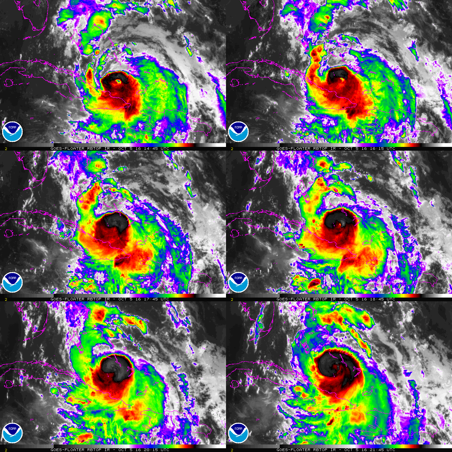
More than two million more people now live in Florida than in 2005, many of them in booming south Florida. The pace of sea level rise is also increasingly apparent — clear-days floods, caused by nothing more than the normal high-tide cycle, now occasionally top levels seen only in past hurricanes. Climate change is happening in Florida, and Thursday’s landfall of Matthew might be the state’s biggest test yet.

(Image: National Oceanic and Atmospheric Administration)
It’s 2016, and all weather now takes place in a different climate context — Hurricane Matthew is no different. A warmer atmosphere holds more water vapor, which is shifting the odds toward more intense rainstorms. Matthew threatened Haiti with up to nine months’ worth of rainfall in a single day. Warm ocean water is one of the main ingredients hurricanes need to intensify. Earlier in its lifecycle, Matthew became one of the three most rapidly intensifying hurricanes ever observed in the Atlantic — all three have happened since 2005. There’s some recent science that shows hurricane season could be getting longer as the oceans warm and favorable conditions become more common. Matthew is now the longest-lasting Category 4 or 5 hurricane during October ever seen in the Atlantic — the latest in a string of recent eye-opening tropical cyclones around the world.
Even for Florida, Matthew is a path-breaking storm. For example, many of the buildings at Kennedy Space Center in Cape Canaveral — which is in the direct path of Matthew and already very vulnerable to rising seas — were built to withstand winds of up to 125 mph, and may suffer “severe” damage, according to Eric Berger, a science journalist with a focus on space.
Matthew lost some energy crossing over Haiti and Cuba on Tuesday, but conditions in the Bahamas and offshore Florida are nearly ideal for re-strengthening. Matthew will be passing over the Gulf Stream current, which is record warm for this time of the year.
Current forecasts show Matthew hitting Florida as a Category 4 late on Thursday, but as the National Hurricane Center has repeatedly cautioned, the storm will be taking a wildcard path roughly parallel with the coastline. That means with a slight change in track Matthew’s highly dangerous center could either hug the shoreline for more than 24 hours, or it could remain a bit more safely offshore. Recent weather model trends have increased the chances of the first, shore-hugging scenario.
And Matthew may not be done with Florida after this week. The latest weather models are starting to hint of a possible loop back southward with a second landfall sometime next week — a weird but plausible end for a historic storm.


