Weather in the Caribbean right now looks ripe for a hurricane — but we might not know for sure until it’s too late.
By Eric Holthaus
Hurricane Wilma is shown from space on October 23, 2005 — the last hurricane to make landfall in Florida. (Photo: NOAA/Getty Images)
There’s an area of disturbed weather right now in the Caribbean, near the U.S. Virgin Islands, that’s getting a lot of buzz among meteorologists. This fact alone — that a tropical system that hasn’t even formed yet is raising experts’ eyebrows — is noteworthy.
As we saw earlier this month with the Louisiana floods, a storm doesn’t need a name to create catastrophic damage. In this case, though, we’re still talking about a potential storm — which, in a reasonable worst-case scenario, could provide a double-hurricane strike in Florida and the Gulf Coast next week.
So, let’s take a closer look. There are two main questions here: First, will these diffuse showers and thunderstorms (officially known for the moment as “Invest 99L”) ever congeal into an official, nameable tropical system? (“Hermine” is the next name on the list of storm names for the Atlantic Ocean.) Second, if Hermine forms, where will it go?
We may not know the answer to the first question for another day or two, which complicates the answer to the second question. Here’s why: One of our most accurate, highest-resolution hurricane models — the Hurricane Weather Research and Forecast system — has been strongly hinting that nothing much will happen with 99L until late Saturday or early Sunday, at which point a period of rapid intensification could make the storm blossom quickly into a hurricane.
This is situation that worries me: This morning's HWRF showed potential for rapid intensification of #99L near FL: pic.twitter.com/yMfuK7DurR
— Eric Holthaus (@EricHolthaus) August 24, 2016
This is probably my biggest worry: That a no-name storm will meander northwestward through the Bahamas, and then — wham! — it becomes a hurricane overnight under the influence of the near record-warm Gulf Stream, hitting South Florida the next day (Sunday or Monday). At the moment, I’d give the above scenario about a 25 percent chance of occurring.If it happens, Hermine would be Florida’s first hurricane landfall in nearly 11 years — a record-long streak for a state that’s gained more than two million new residents and billions of dollars of coastal property in the last decade.
The danger here is significant: The National Hurricane Center, by policy, does not issue official advisories until a storm meets certain technical criteria, including the presence of a well-defined wind circulation. That means, in a worst-case scenario, like what’s depicted above, residents of South Florida might receive little or no official warning before Hermine makes landfall. (In March, the NHC released a statement saying it may change this policy starting in 2017, at the earliest.)
A blend of all available data — which is probably the most responsible way to forecast a storm like this — shows the storm will likely reach tropical storm status sometime between Thursday and Sunday.
The HWRF has shown a scenario similar to the above in three of its last four iterations, so it’s a real possibility that Hermine will form and hit Florida. It’s also echoed by the model from the European Center for Medium-Range Weather Forecasting — considered by many meteorologists as the best and most reliable model in the world, which has at times shown a similar potential for the weather’s rapid intensification in the Bahamas.
In contrast, several other reasonably reliable models (most notably the National Oceanic and Atmospheric Administration’s flagship Global Forecast System model) predict nothing much from 99L at all, at any time. I’d also give the following scenario about a 25 percent chance of occurring: 99L continues to fizzle into oblivion.
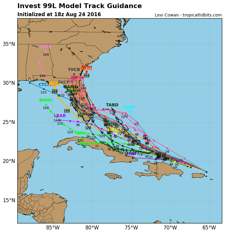
The middle 50 percent of probability, naturally, is what’s most likely to happen: 99L will gradually continue to gain organization, and track across Florida as a tropical storm. A blend of all available data — which is probably the most responsible way to forecast a storm like this — shows the storm will likely reach tropical storm status sometime between Thursday and Sunday.

(Map: Levi Cowan/TropicalTidbits)
Of course, Hermine probably won’t die out completely once it makes landfall in South Florida. Almost all models, as well as the presence of a disturbingly strong high pressure ridge forecast over the mid-Atlantic this weekend, argue that once Hermine leaves South Florida, it will be pushed westward into the Gulf of Mexico — where water temperatures are also near-record warm.
At that point, there’s enough uncertainty in the forecast — this is still about six or seven days away, at the limit of reliable predictability — that almost anything could happen. Some models, like the ECMWF, have shown Hermine reaching land as a strong hurricane somewhere between Houston and Tampa. Others, like the GFS, have shown it remaining relatively weak.
One thing’s for certain: Louisiana doesn’t need any more rain. In its best-guess outlook, the National Weather Service is now showing 99L approaching Louisiana next Wednesday — though of course that’s subject to change.


