The storm serves as a wake-up call for vulnerable parts of the world in an era of climate change.
By Eric Holthaus
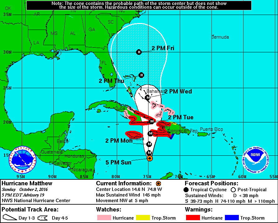
(Image: National Oceanic and Atmospheric Administration)
After becoming one of the fastest-strengthening and strongest hurricanes in the history of the Atlantic basin, Hurricane Matthew is now making a beeline for Haiti, the poorest country in the Western Hemisphere.
Though Matthew will pass close by Jamaica and could make later landfalls in Cuba and the Bahamas, the country at the greatest risk from Matthew is Haiti. Matthew’s closest approach to Haiti will be on Monday afternoon, but its impact could linger for weeks.
As of Sunday afternoon, Matthew’s circulation features 145 mph winds, just 5 mph less than Hurricane Cleo in 1964, the strongest hurricane to hit Haiti in recorded meteorological history (since 1851). Just six hurricanes in that time have made direct landfall in Haiti with winds stronger than 115 mph, the benchmark for a “major” hurricane — the last was Hurricane David in 1979. The last major hurricane to hit Haiti from the south was Hazel in 1954, which killed about 1,000 people.

(Image: National Hurricane Center)
According to Jonathan M. Katz, a New York Times contributor and former Associated Press Haiti bureau chief, the impact of a hurricane like Matthew is a big unknown in Haiti. “There are already warnings going out on the radio, but in Haiti right now, politically, essentially there is no government.” That means that, for many people, Katz says, “there’s nowhere to go. There are no evacuation shelters to go to.” (Katz adds that the government has reportedly opened 1,300 emergency shelters across the country, according to the AP, but that most Haitians won’t have a way to access them.)
Haiti ranks 163 out of 188 world countries in terms of human development, and is relatively densely populated with about as many people as Ohio in a region the size of Massachusetts.
The hurricane is bad timing in Haiti, where the interim government has tentatively scheduled a presidential election for October 9th, and the candidates have continued to campaign in spite of Matthew. To all appearances, Haiti’s fragile government is doing its best to warn its citizens about the coming storm, but is, in large part, leaving preparation to individual families. The only evacuations reported so far in Haiti are of vulnerable barrier islands — as opposed to Cuba and Jamaica, both of which have begun systematic evacuations of regions most at risk.
Since hurricanes rotate counterclockwise, the strongest winds and heaviest rains are usually found on the eastern side of the storm — which means Haiti will take the brunt of Matthew even if the storm’s center remains off the coast.
On Sunday, Haiti’s Interior Ministry issued a ban on regional travel and closed public markets. During a national address that was streamed live on Facebook, Haiti’s Interior Minister François Anick Joseph called Matthew “a big challenge but a chance for us to show our resilience.” On Saturday evening, Haiti’s Department of Civil Protection issued a red alert — its highest warning level. Photographs of bare supermarket shelves in Haiti circulated via social media on Sunday. The Red Cross has already begun pre-positioning relief supplies and disaster recovery personnel to Haiti. The United Nations also has about 5,000 peacekeepers permanently based in Haiti.
In past tropical storms and hurricanes in Haiti, it has been rain, not wind that’s been most destructive. Widespread inland flooding from heavy rains falling on eroded hillsides has caused road and bridge washouts, crop failures, malnutrition, and public-health emergencies from waterborne diseases like cholera. About 60,000 people are still displaced in Haiti from a major earthquake in 2010 that killed more than 200,000 people. The country’s capital, Port-au-Prince, is located near a giant river valley, with mountains on all sides — sheltered by the wind, but vulnerable to flooding.
Matthew’s inner core is fierce but relatively small — but that won’t necessarily limit the damage in Haiti. Since hurricanes rotate counterclockwise, the strongest winds and heaviest rains are usually found on the eastern side of the storm — which means Haiti will take the brunt of Matthew even if the storm’s exact center remains slightly off the coast. Though Matthew’s hurricane-force winds extend only about 35 miles from the center, the National Hurricane Center has noted that “a persistent, but inexplicable” mass of thunderstorms extends about 200 miles eastward from the center — and is expected to bring truly torrential rainfall over most of southern Haiti.
The latest weather models and National Hurricane Center analysis estimate that as much as 15 to 40 inches of rain — up to nine months’ worth — could fall in the day or two it will take Matthew to track across the country. Coastal flooding could also be severe — storm surge could temporarily raise sea levels in southern Haiti by 10 to 15 feet, with waves of up to 30 feet just offshore. The National Hurricane Center warns that Matthew’s heavy rainfall “will likely produce life-threatening flash floods and mud slides.”
Katz says that, no matter Matthew’s impact in Haiti, the storm serves as a wake-up call for vulnerable parts of the world in an era of climate change. Heavier rainfall, stronger hurricanes, worsening crop production, and rising sea levels are all particularly pronounced in Haiti, and are all expected to worsen in the coming decades. “People [in Haiti] are very self-sufficient,” Katz says, “but a hurricane is just not the kind of situation where self-sufficiency does the trick.”
After leaving the Caribbean, Matthew could affect the United States later in the week, though that forecast is still very uncertain. On Sunday, the National Weather Service began a series of special weather balloon launches from its eastern offices to help gather additional data to improve the forecast.


