As Los Angeles re-thinks the pathetic concrete riverbed at its core, one hydrologist is asking developers to remember the spectacular floods of its past.
By Willy Blackmore
(Photo: Joe Toreno)
On a hot, cloudless day in August, we stood on the bed of the Los Angeles River, the slanted concrete bleached white by the sun. L.A. Mayor Eric Garcetti and Frank Gehry were scheduled to present details about a study of the waterway that the 86-year-old architect and his firm had been commissioned to conduct nine months prior — a study that would take the entire 51-mile stretch into account, with an eye toward eventually transforming it into a “linear Central Park.” But back surgery kept the white-haired visionary from making an appearance, and Garcetti skipped the event too. The descent into the river after the presentation had turned into little more than a photo opportunity, with a crew of reporters gathering color for their stories as architects, engineers, and others milled about.
I was standing in the shade of the Sixth Street Viaduct, taking in the gentle flow of the river, when one of the suited engineers being photographed suggested I move a few steps back. If you don’t stand underneath the bridge itself, Mark Hanna told me, you might get hit by a bottle tossed out of a car passing overhead.
“The concrete is not there for today. It’s there for when nine inches of rain fall, another five-inch storm is on the horizon, and the Pacific Ocean is stacking up two more mothers of all storms.”
That, in a way, is Hanna’s job: Telling people about the river, how it works, and what they need to do in order to make it work for them. Even if that simply means how to avoid projectiles at its bottom. As a hydrologist at Geosyntec, a scientific and engineering consulting firm, Hanna has his hand in many of the ambitious water- and river-related projects underway in L.A. As the city seeks to bolster its green bona fides and re-consider its more than century-old water system, people are embracing the channelized river after decades of civic and public neglect. Institutions from Gehry Partners to the Los Angeles Department of Water and Power are turning to Geosyntec and Hanna for hydrological guidance. Because — whether it’s a $1.3 billion federal habitat-restoration project along the river’s Glendale Narrows or artist Lauren Bon’s plan to install a 72-foot-wide water wheel on its banks — in order for the city to survive, the river’s numerous hydrological functions must be preserved.
That’s not an exaggeration, as Hanna, who looks a bit like a shorter Troy Aikman, recently explained when we met again over coffee in downtown’s Arts District. We were sitting about a block away from the river’s bank on a property that was likely inundated after a deadly string of storms and flooding in 1938. Those events ultimately resulted in the river’s course being set in concrete. But when Hanna thinks about worst-case scenarios, he looks back further, to the period when the first Spanish missionaries made their way up into present-day California from Mexico.

This story first appeared in the May/June 2016 issue of Pacific Standard.
“The Crespí expedition, when it came up the coast, they had to go all the way up to where the 210 is” — the Foothill Freeway, at the base of the San Gabriel Mountains, some 40 miles from the water — “to get across, and then go back out to the coast. There was just no way to get across.”
To call what the missionaries found a mess is an understatement: Before channelization, the surging L.A. and San Gabriel rivers bled into each other during exceptionally wet winters, spreading not only floodwater but huge amounts of debris across the entire Los Angeles Basin. In such years, the floodplain stretched south into what is now Orange County, and all the way out to present-day Santa Monica to the west. Hanna ticked off the years that would’ve seen that sort of event, had the rivers not been channelized: 1983, 1998, 2005–06. “And this year might be one of those times,” he said. Today, of course, the basin that Juan Crespí and Gaspar de Portolá couldn’t cross in 1769 is home to more than 18 million people, Hanna and myself included.
But flooding was also vital to a younger Los Angeles. Eons of floodwaters had trickled down into underground aquifers that could be tapped with wells, and the river provided a seasonal supply of surface water for drinking and irrigation. Until William Mulholland figured out how to drain the Eastern Sierra for Los Angeles’ benefit — importing water first, in 1913, from the Owens Valley, and eventually from farther up the Mono Basin — the L.A. River was the city’s primary water source. Once the Los Angeles Aqueduct began to turn the Owens Valley into dust, spilling the water down the mountains to the city, that “sealed the fate of the L.A. River as we know it,” as Hanna put it. No longer needed as a water source, it was feasible two decades later to turn the river into a flood control channel for getting rid of rainfall instead of holding onto it.
Hanna began his career in 2003 at the LADWP, the utility that grew out of Mulholland’s aqueduct, and his first job after finishing his doctoral degree at the University of California-Los Angeles was working at the Lee Vining Intake — 338 miles away from Los Angeles, the northernmost reach of the department’s infrastructure. But the system wasn’t simply diverting the creek into Angelenos’ faucets: Hanna worked on a project that allowed high flows to run past the intake and down through the streambed, replenishing the ecosystem with water and nutrient-rich sediment.

(Photo: Joe Toreno)
Hanna’s brain is well suited to the type of work that balances human engineering with nature’s high-functioning systems. “I can visualize when the flood comes and the rocks jump and the sand moves,” he said, his hands shaking excitedly, miming how boulders are tossed about by floodwaters, “and the nutrients get up on the floodplain and then the fish get up there for refuge and then when the flood recedes the fish go back in and everything works.” He has a deep respect for how elegant the cycle is — and an informed fear of the havoc it can unleash on buildings and people that get in its way.
When people come to Geosyntec with restoration projects that involve getting rid of concrete — whether from the banks of the river, or across its 800-square-mile watershed — the risk of catastrophic flooding has to be considered. The tall, slanted banks of the waterway may be unsightly, but they keep potential overflows at bay. Still, the threat of floods can be easy to forget in a place like L.A., which is in the midst of a historic drought. Even as El Niño-driven storms drenched parts of the state, the city’s rainfall remained below average during the winter of 2015–16.
Before channelization, the surging L.A. and San Gabriel rivers bled into each other during exceptionally wet winters, spreading not only floodwater but huge amounts of debris across the entire Los Angeles Basin.
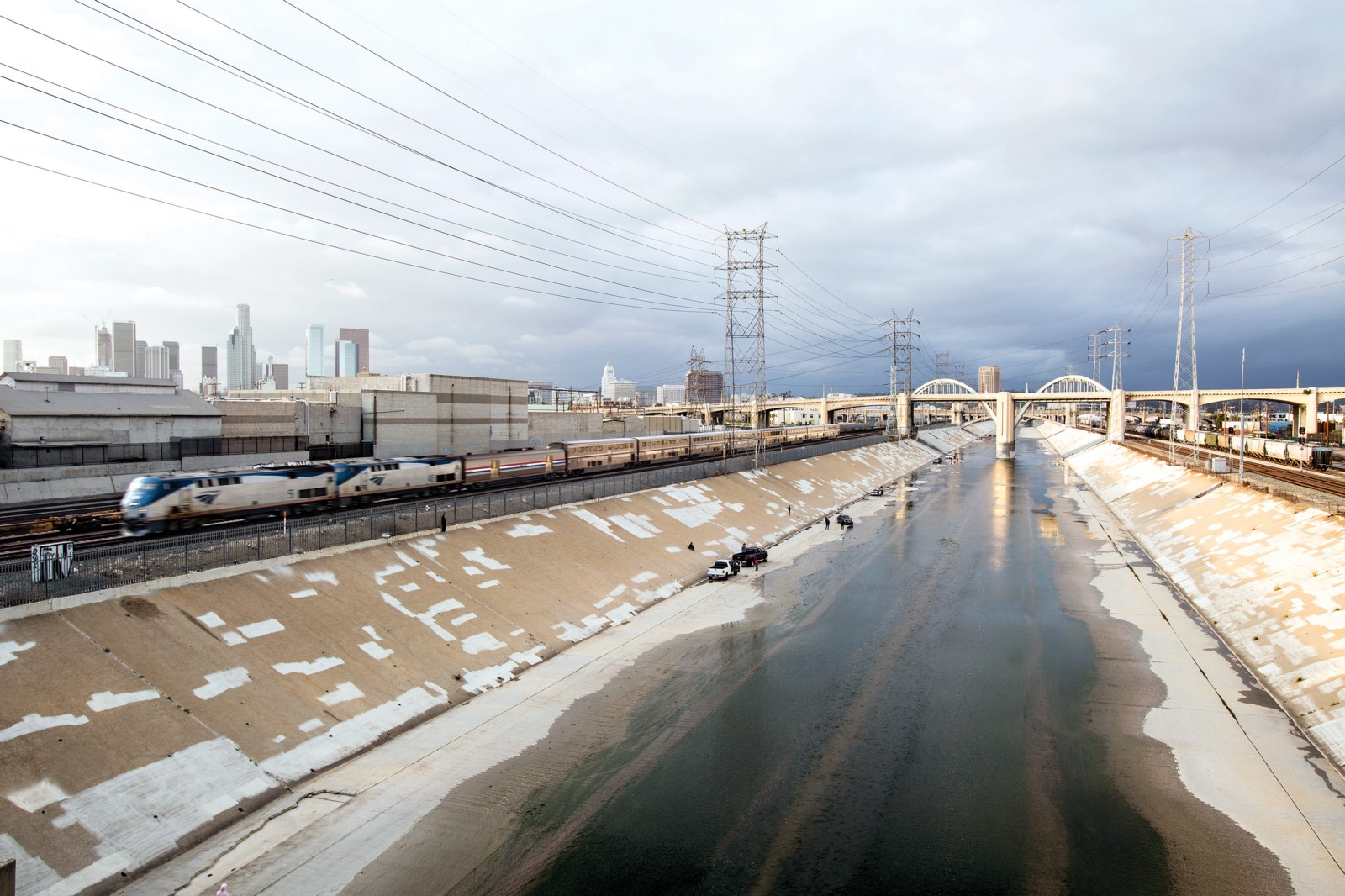
As we walked across the 7th Street Bridge, the river looked almost pathetic: Little more than a trickle was running through the center of the massive channel, 90 percent of it originating at wastewater treatment plants. On such a day — an average day — it seems completely reasonable to tear out the banks, add in a bit of space for public parks and wildlife habitat, and turn the grey ribbon into a green one. And with the proper precautions, you can — but it’s by no means simple.
“The concrete is not there for today,” Hanna explained, “and it’s not there even for the last storm that we had,” which brought three inches of rain and countless cell phone videos of a surging river to Twitter and Instagram. “It’s there for when nine inches of rain fall, another five-inch storm is on the horizon, and the Pacific Ocean is stacking up two more mothers of all storms — that’s peak flow.”
One of the projects Geosyntec has consulted on is LADWP’s new stormwater capture master plan, an ambitious concept that could see L.A. relying on local rainfall for as much as 30 percent of its water needs by 2035. Implementing this vision would involve re-orienting the current system so that more water goes into storage or groundwater basins — like rain barrels or mulched open spaces — before it moves down the watershed and into the river.
But for all of the good they’ll do to bolster local water resources, the rain barrels, the infiltration basins, and all the other kinds of low-impact developments proposed in the stormwater capture plan will not be enough to offset the threat of a flooding river. “When we need that concrete — when we really need it,” Hanna said, “everybody’s rain barrel is long overflowing. Everyone’s cistern is long overflowing. It’s been overflowing for weeks. And then that storm hits.”

||


