Scientists have been using drones for decades, but as they become more affordable and portable, they’re proving critical to studying—and saving—our most vulnerable environments.
By Mary Catherine O’Connor
David Johnston with an eBee Sensefly drone. (Photo: Scott Taylor/Duke University Marine Laboratory)
Journalists like to lean on anecdotes to tell stories about climate change, but for climate scientists, data is everything. But data collection is seldom a quick or inexpensive task, especially when that data is best acquired via a bird’s eye view of, say, an undulating coastline or a vast expanse of ice.
Fortunately, drones (also known as unmanned aerial vehicles [UAVs], or unmanned aerial systems [UASs]) can serve as robotic avian minions, filling niches for which the conventional methods of aerial data collection — like chartering planes or tapping into satellite data — are poorly suited.
Drones are not new, nor are climate scientists only now discovering their utility as research tools. “Back in 1998, we used what was considered a smaller UAV at that time” for studying ice cover in the Arctic, says James Maslanik, a research professor emeritus from the aerospace engineering sciences department at the University of Colorado-Boulder. “It was a cutting-edge system, it was way ahead of its time,” he says of the fixed-wing UAV they employed. It had a three-meter wingspan, a four-kilogram payload limit, and was gas-powered. Maslanik recalls having to drag 50-gallon drums of aviation fuel up to their research station in the Arctic just to get the UAV in the air.
Today’s drones — both rotor-based designs, like quadcopters, and fixed-wing versions, which look like shrunken conventional planes — are far more affordable, portable, usable, and capable than what Maslanik was working with a decade ago. That’s thanks to the miniaturization of their electronic components, the falling price and size of the cameras and sensors that they carry, and the capabilities of their propulsion systems, which in most cases are now battery powered.
More Nimble, Accessible
Prior to the emergence of drones, aerial surveys could only be done through the use of manned aircraft or by accessing satellite images, but both of these approaches have significant limitations.
Chartering a plane is generally far more expensive than using a drone and less reliable, since weather can quickly stymie a flight plan. Plus, chartering a plane generally means scheduling it days in advance. By contrast, researchers do need the Federal Aviation Administration’s permission to operate a drone, but once they have it, they can use the devices whenever they want, as long as wind speeds are within the particular UAV’s threshold.
David Johnston, an assistant professor at Duke University’s Nicholas School of the Environment, says of the switch from chartering planes to using UAVs: “We can go from [launching a drone] to having workable data in four hours, versus maybe four days if we’re using an airplane.”
Plus, a drone is more nimble than manned aircraft and can be piloted at lower altitudes. Satellite imagery has been a boon to researchers, but cloud cover can make it useless, and it often lacks the resolution needed to do precise work, such as counting animals.
It might sound mundane, but counting animals is a key part of climate research in coastal areas, where population dynamics are strongly tied to changes in factors such as water temperature, food sources, or the loss of sea ice. In early 2015, Johnston led a team that used small fixed-wing drones — the eBee senseFly manufactured by Parrot — to count gray seals along the icy shores of islands off Newfoundland and Labrador. The species was nearly extirpated in the 1820s, but its numbers have been growing since the 1980s. Today, it faces multiple threats from climate change: warmer temperatures have had impacts on its breeding patterns, and, in the Arctic, melting ice is exposing the seals to a deadly parasite.
The team wanted to determine whether drones could make the work of counting the animals and their pups easier and less time consuming than the alternative aerial approach. In prior censuses, researchers would use a camera (usually hand-held) to shoot from an airplane or helicopter, and then manually stitch the resulting images together — hoping not to count any seals twice.

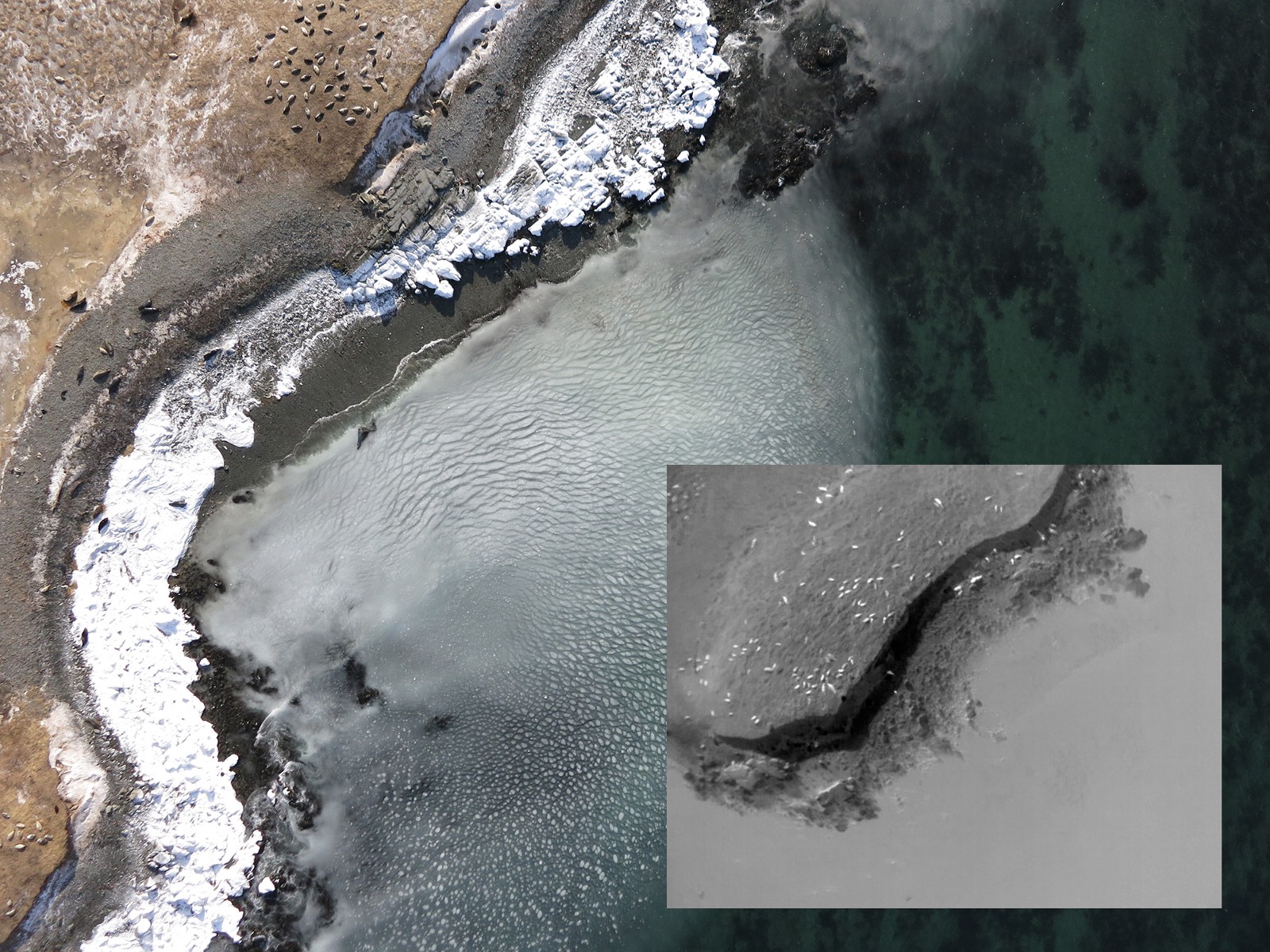
Gray seals along the Newfoundland Shore as photographed by the Duke University team. The inset photo shows the seals as photographed with the thermal imaging camera. (Photos: David Johnston/Duke University Marine Laboratory)
There turned out to be significant benefits to using drones instead: In addition to snapping images and video, the software in the drones used GPS data to geo-reference each captured frame. This data was later used to create what are called orthomosaic maps, which were more accurate and useful than manually stitching together images shot from a handheld camera.
Plus, one of the eBee drones that Johnston’s team used to count seals also carried a thermal video camera, which detects heat, thereby making the seals and pups plainly visible even if they were obscured by a tree or bushes.
This spring, the team will bring the drones to Cape Cod to conduct more gray seal surveys.
Cold to Hot
In warmer waters, coral reefs play a vital role in ocean health. But climate change — specifically, warming oceans and rising acidity from growing rates of dissolved carbon dioxide — has already inflicted significant damage on coral reefs. In the Caribbean, corals are also suffering because key species that feed on the algae the corals harbor, including parrotfish and sea urchin, are in serious decline. That loss, plus nutrient loading from agricultural runoff, leads to too much algae, which chokes the coral.
A 2014 report from International Union for Conservation of Nature predicted the total demise of Caribbean coral in 20 years — unless they can be brought back into balance. The Nature Conservancy is working throughout the Caribbean to help protect and foster healthy coral reefs and encourage sustainable fishing practices.
Against the odds, an important coral species — Acropora palmate, or elkhorn coral — is making a comeback in some of these areas. But counting and mapping this coral is difficult because it grows in shallow water and is exposed during periods of low tides, which means the conventional method of counting corals by snorkeling over them won’t work. But TNC senior scientist Steve Schill is using quadcopter and hexacopter (four and six rotor, respectively) drones to collect video of the coastline and count and map the resilient elkhorn.
Schill, a geographer and spatial modeler, also uses UAVs to create maps of Caribbean mangroves, which are an important mitigation source against climate change. Mangroves sequester more carbon than other forest types and act as nurseries for many fish species which later venture out to join coral reef ecosystems. Mangroves are also victims of coastal development, and the National Oceanic and Atmospheric Administration estimates that more than half of the world’s mangroves have been destroyed over the past century. Outfitted with near infrared cameras, the drones collect images that show the researchers where the mangroves are under stress from low water or nutrients.

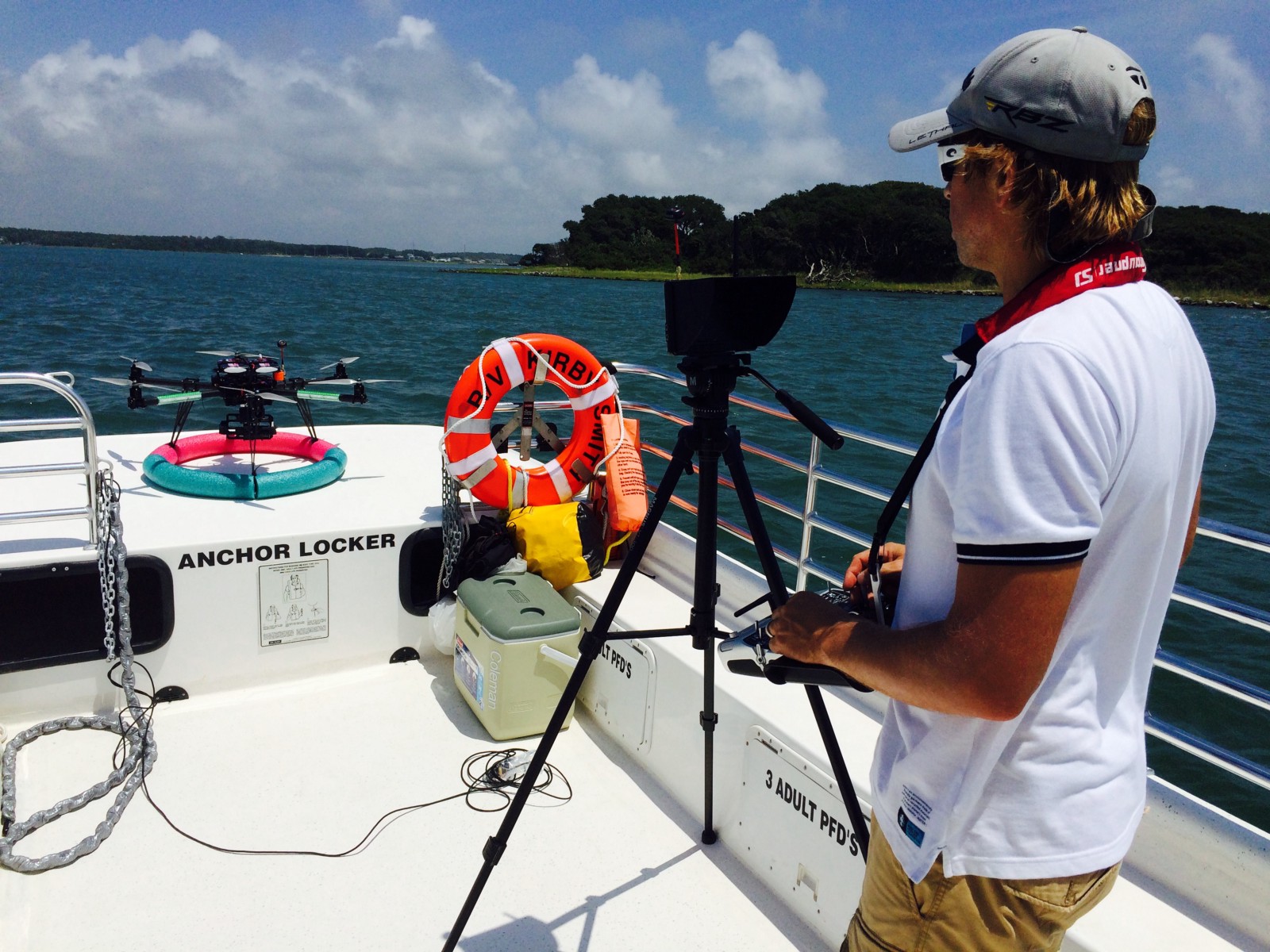
A researcher launches a CineStar six-rotor drone from a boat in the Caribbean.
Mapping mangroves and corals might not be conservation’s sexiest work, but it plays a vital role, Schill says. These maps are the first step in modeling future changes, and it is those models that show local governments and policymakers why action is important. “If we can protect 20 percent of reefs, what is the best 20 percent to protect? These maps help us understand where to spend our conservation dollars,” he says.
Plus, these are not your average maps. Schill uses photogrammetry, a technique that converts 2-D images into 3-D models by precisely measuring the distance between features in the images, to create maps that literally jump off the page. Drones enable photogrammetry of coastal areas by collecting still images and video from scores of oblique, top-down, and lateral perspectives, which are pulled together into image mosaics and pieced together to form 3-D representations. The software needed to create these images has, like drones themselves, become far more accessible and user-friendly in recent years.
The resulting images are accurate down to two centimeters, so these maps can convey precise heights of features (such as the mangrove canopies) through gradients of color.
Drones for Improving Climate Models
In the largely (but decreasingly) white Arctic, Gijs DeBoer uses UAVs to gather data that is helping to make climate models more accurate. DeBoer is a research scientist for the Cooperative Institute for Research in the Environmental Sciences, a partnership between the NOAA and the University of Colorado-Boulder, and he studies clouds — specifically, the role that clouds play in the transfer of energy between the atmosphere and the Earth’s surface.
Arctic researchers worry a lot about albedo, which refers to the degree to which a surface reflects or absorbs sunlight. As the Arctic melts, its ice turns to water, which absorbs more sunlight. Wind-blown dust and soot deposits (originating from either the industrial and transportation sectors or wildfires) worsen the situation. “Ultimately, this [loss of reflectivity] results in a feedback mechanism, wherein the warming melts the ice which changes the albedo, and a darker surface absorbs more radiation and leads to further warming,” DeBoer says.
Clouds are reflective, so where they cover the Arctic, they reflect the sun’s energy back into the atmosphere. Yet studying the physical processes that underlay clouds and their formation has been very difficult because scientists lack good observational data and models. Data has come either through narrow observations — measuring radiation in single, discrete locations — or data collected by radiometers mounted on manned aircraft. But planes move too fast to get the granularity that DeBoer needs to study clouds and that climate modelers need in order to integrate the role of clouds into their climate forecasts.

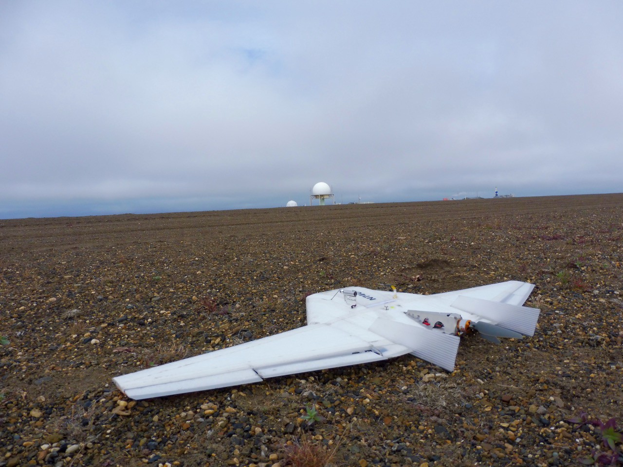
A DataHawk 2 unmanned aerial vehicle in Prudhoe Bay, Alaska. (Photo: William Finamore)
For the last two years, DeBoer and his CIRES team have been using fixed-wing drones in Prudhoe Bay, Alaska. The drones carry radiometers that measure the energy coming down through the atmosphere as well as the energy coming up from the surface, to see what percentage of that downward energy is being reflected back up. This type of research requires surveying large swaths of land, which CIRES would not be able to do elsewhere in Arctic territory controlled by the United States, because the FAA requires drone pilots to keep visual contact with the drones at all times. But DeBoer’s team uses airspace in which the Department of Energy, in coordination with the FAA, allows drones to be flown well beyond a pilot’s view-shed, along the coast and over the Arctic Ocean to 82 degrees north, some 700 nautical miles from shore.
“UAVs are really at the forefront of improving climate models” by helping scientists better understand the energy transfers between the surface and atmosphere, DeBoer says. “They will help us get a more accurate representations in both the short term — the next few years — and the longer term of climate evolution. There is inherent uncertainty in doing this sort of [climate modeling] work and one of the things we focus on is trying to reduce that uncertainty. And that feeds into how policymakers and industry can use these projections in a meaningful way” to mitigate the impacts of climate change.
A Tool, Not a Panacea
Looking ahead, drones are only going to become a more important, capable research tools, especially as they become more integrated with other advanced technologies. Schill and his colleagues, for example, are developing a remote-controlled boat which will tow an underwater camera. His team will deploy the boat along with a drone to collect imagery both under and above the water in order to create maps that give both a bird- and a fish-eye view.
Johnston says he’d like to collect day-to-day archive footage of coastlines so that researchers can better understand how weather events shape them over time. Say there is a major topographical change that occurs along a coastline, and it could be the result of a powerful storm or the result of a sinkhole. Without good data, you wouldn’t be able to tell which was the cause. “If you had two images taken two weeks apart, you’d see something changed, but you wouldn’t have measurements in the middle,” Johnston explains.
He says that, in coastal areas, through frequent monitoring, drones can help researchers differentiate between “detecting change and detecting how change occurs.”
Drones come with some serious societal baggage and can be misused, as seen this past summer, when hobbyist pilots flew their gadgets in airspace near wildfires, forcing officials to ground firefighting aircraft. They are also not always the best tool for the job. Their noisy rotors can disrupt the wildlife that researchers are trying to study. Their range and technical capabilities, though improving, are still limited. And regulations around how, where, and when UAVs can be flown are still in flux. And then there are the financial constraints, which place an inescapable gap between the UAV technology these researchers are using today and what they would be using if they had unimpeded cash flow.
But for Johnston, Schill, DeBoer, and the many other scientists whose work takes them to the water’s edge, UAVs are opening up new research possibilities and deepening the scientific record in ways that are having measurable impacts on our understanding of — and response to — changing ecosystems and the melting Arctic.

||
The Conservation in the Age of Climate Change Project is an effort to explore how conservation organizations around the world are responding to rising seas, droughts, extreme weather events, and other threats posed by global warming.


